Chautauqua Creek fishing guide
A 20-mile river in Chautauqua County, New York. The state agency lists 3 species here and last stocked it in October 2025. It has 1 public access point and 1 live sensor on the water.
Today's fishing forecast
LiveLoading today's forecast…
Hour by hour
Bite windows
Next 7 days
Live sensors on this water
- Chautauqua Creek below Westfield NY · flow, water level · USGS 04213319
Chautauqua Creek flow
Flow gauge: Chautauqua Creek below Westfield NY, USGS 04213319 . The forecast above shows its latest reading and band: Fishable up to this month's typical high (75th percentile), High up to the 90th percentile, Blown out above that.
Typical flow by month
Typical is the middle half of daily mean flows in that month (25th to 75th percentile), from 9–10 years of USGS records.
| Month | Typical flow (cfs) | Median (cfs) | Blown out above (cfs) |
|---|---|---|---|
| January | 40–111 | 58 | 246 |
| February | 37–102 | 54 | 227 |
| March | 63–154 | 94 | 256 |
| April | 51–115 | 76 | 206 |
| May | 23–58 | 34 | 99 |
| June | 9–22 | 14 | 42 |
| July | 6.8–18 | 11 | 46 |
| August | 5.9–15 | 9.3 | 29 |
| September | 5.2–14 | 8.2 | 31 |
| October | 9.5–47 | 19 | 117 |
| November | 36–110 | 71 | 204 |
| December | 54–143 | 81 | 263 |
Fish species in Chautauqua Creek
Species on the official fishing-waters list from New York State Department of Environmental Conservation. Species links open our guide to that fish in New York.
| Species | Status | Last stocked |
|---|---|---|
| Brown Trout | Agency list | — |
| Rainbow Trout | Agency list | Oct 2025 |
| Steelhead | Agency list | Mar 2025 |
Stocking history
Last stocked October 2025: rainbow trout yearling. 19 stocking records in the last 10 years, 340,200 fish in all, from New York State Department of Environmental Conservation. Each row below sums the agency's records for one month, species and size.
| Date | Species | Size | Fish stocked |
|---|---|---|---|
| Oct 2025 | Rainbow Trout | yearling | 10,000 |
| Mar 2025 | Steelhead | fingerling | 25,000 |
| Oct 2024 | Rainbow Trout | yearling | 10,000 |
| Mar 2024 | Steelhead | fingerling | 25,000 |
| Oct 2023 | Rainbow Trout | yearling | 10,000 |
| Mar 2023 | Steelhead | fingerling | 25,000 |
| Oct 2022 | Rainbow Trout | yearling | 10,000 |
| Mar 2022 | Steelhead | fingerling | 20,000 |
| Oct 2021 | Rainbow Trout | yearling | 10,000 |
| Mar 2021 | Steelhead | fingerling | 20,000 |
| Oct 2020 | Rainbow Trout | yearling | 10,000 |
| Mar 2020 | Steelhead | yearling | 25,000 |
| Oct 2019 | Rainbow Trout | fingerling | 4,000 |
| Oct 2019 | Rainbow Trout | yearling | 10,000 |
| Mar 2019 | Steelhead | fingerling | 25,000 |
| Oct 2018 | Rainbow Trout | yearling | 11,200 |
| Apr 2018 | Steelhead | fingerling | 50,000 |
| Apr 2017 | Steelhead | fingerling | 40,000 |
Plus 1 stocking record before October 2016 in the agency data.
Public access and boat launches
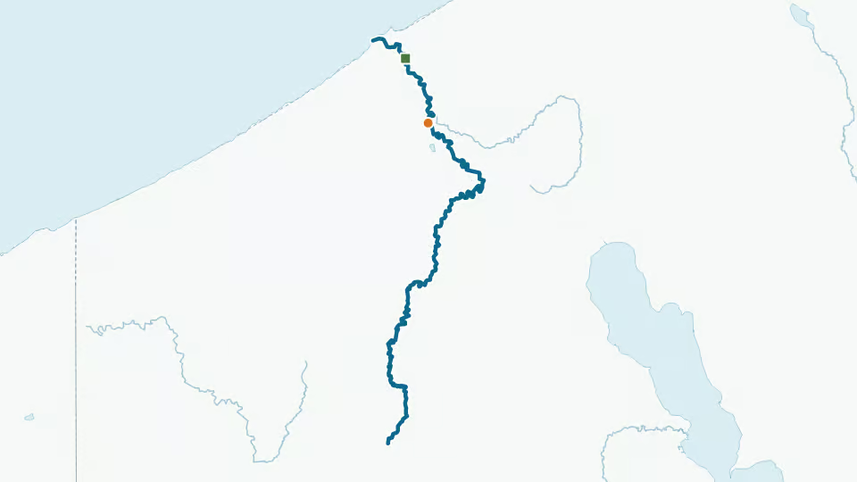
1 shoreline access site from New York State Department of Environmental Conservation; orange dots on the map above.
- Chautauqua Creek fishing access (Chestnut St)Shore
Regulations
No special regulations for Chautauqua Creek in our data. New York statewide rules apply unless the agency lists a special rule for this water. Seasons, limits and size rules change: check New York fishing regulations before every trip.
Licence: New York fishing licences from New York State Department of Environmental Conservation.
Chautauqua Creek fishing FAQ
What fish are in Chautauqua Creek?
New York State Department of Environmental Conservation lists 3 species for Chautauqua Creek: brown trout, rainbow trout and steelhead.
When was Chautauqua Creek last stocked?
New York State Department of Environmental Conservation last stocked Chautauqua Creek in October 2025 with rainbow trout. Our data has 19 stocking records in the last 10 years.
Is there public access to Chautauqua Creek?
The agency lists 1 shoreline access site for Chautauqua Creek. Each one is listed in the access section with parking and toilets where the agency records them.
Is there a flow gauge on Chautauqua Creek?
Yes. USGS gauge 04213319 (Chautauqua Creek below Westfield NY) measures flow on Chautauqua Creek. Its median daily flow runs from about 8.2 cfs in September to 94 cfs in March. Today's reading is in the forecast at the top of this page; the flow section has the typical range by month.
Sources: New York State DEC, Recommended Fishing Lakes and Ponds (mw8j-wduf); Recommended Fishing Rivers and Streams (tjny-fki3), on data.ny.gov · New York State DEC, Public Fishing Rights parking areas (9vef-6whi), on data.ny.gov · New York State DEC, Fish stocking lists on data.ny.gov · U.S. Geological Survey, Geographic Names Information System, domestic names · U.S. Geological Survey, National Hydrography Dataset, high resolution, state geodatabases (NHDWaterbody, NHDFlowline); 3DHP when it replaces it · U.S. Geological Survey, Water Data OGC API (monitoring locations, discharge, gage height, water temperature). Checked: Oct 4, 2026. Official links open the agency page. How we use data