Lake Erie fishing guide
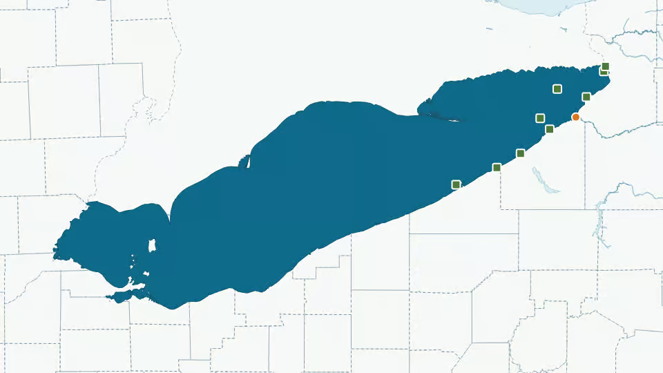
A 6,360,020-acre lake touching 11 New York counties: Erie, Erie, Ottawa, Monroe, Lucas, Erie, Chautauqua, Sandusky, Cuyahoga, Lake and Ashtabula. The state agency lists 9 species here and last stocked it in April 2017. It has 1 public access point and 9 live sensors on the water.
Today's fishing forecast
LiveLoading today's forecast…
Hour by hour
Bite windows
Next 7 days
Live sensors on this water
- Buffalo Buoy · water temperature, wind · NOAA 4403586
- Port Colborne · water temperature, wind · NOAA 45142
- Dunkirk Buoy · water temperature, wind · NOAA 45220
- Barcelona Harbor, NY · water temperature, wind · NOAA barn6
- 9063020 - Buffalo, NY · water temperature, wind · NOAA bufn6
- 9063028 - Sturgeon Point, NY · water temperature, wind · NOAA pstn6
- Dunkirk, NY · water temperature, wind · NOAA dbln6
- Beach 2 Tower · water temperature, wind · NOAA bctp1
- Northeast Marina, PA · water temperature, wind · NOAA nrep1
Fish species in Lake Erie
Species on the official fishing-waters list from New York State Department of Environmental Conservation. Species links open our guide to that fish in New York.
| Species | Status | Last stocked |
|---|---|---|
| Brown Trout | Agency list | Apr 2017 |
| Channel Catfish | Agency list | — |
| Common Carp | Agency list | — |
| Lake Trout | Agency list | — |
| Muskellunge | Agency list | — |
| Rainbow Trout | Agency list | Apr 2017 |
| Smallmouth Bass | Agency list | — |
| Walleye | Agency list | — |
| Yellow Perch | Agency list | — |
Stocking history
Last stocked April 2017: brown trout yearling and rainbow trout catchable. 5 stocking records in the last 10 years, 37,480 fish in all, from New York State Department of Environmental Conservation. Each row below sums the agency's records for one month, species and size.
| Date | Species | Size | Fish stocked |
|---|---|---|---|
| Apr 2017 | Brown Trout | yearling | 36,480 |
| Apr 2017 | Rainbow Trout | catchable | 1,000 |
Plus 5 stocking records before October 2016 in the agency data.
Public access and boat launches
1 boat ramp from New York State Department of Environmental Conservation; orange dots on the map above.
- Lake Erie boat launchRamp
Regulations
No special regulations for Lake Erie in our data. New York statewide rules apply unless the agency lists a special rule for this water. Seasons, limits and size rules change: check New York fishing regulations before every trip.
Licence: New York fishing licences from New York State Department of Environmental Conservation.
Lake Erie fishing FAQ
What fish are in Lake Erie?
New York State Department of Environmental Conservation lists 9 species for Lake Erie: brown trout, channel catfish, common carp, lake trout, muskellunge, rainbow trout, smallmouth bass and walleye, plus 1 more in the table above.
When was Lake Erie last stocked?
New York State Department of Environmental Conservation last stocked Lake Erie in April 2017 with brown trout and rainbow trout. Our data has 5 stocking records in the last 10 years.
Where can I launch a boat on Lake Erie?
The agency lists 1 boat ramp for Lake Erie, near Sunset Bay. Each one is listed in the access section with parking and toilets where the agency records them.
How big is Lake Erie?
Lake Erie covers about 6,360,020 acres; depth is not in our data yet (USGS National Hydrography Dataset).
Is there a water temperature sensor on Lake Erie?
Yes. Buffalo Buoy, Port Colborne and Dunkirk Buoy report water temperature; the latest reading is in today's forecast at the top of this page.
Sources: NOAA NDBC, National Data Buoy Center stations and observations · New York State DEC, Boat launch sites · New York State DEC, Recommended Fishing Lakes and Ponds (mw8j-wduf); Recommended Fishing Rivers and Streams (tjny-fki3), on data.ny.gov · New York State DEC, Fish stocking lists on data.ny.gov · U.S. Geological Survey, Geographic Names Information System, domestic names · U.S. Geological Survey, National Hydrography Dataset, high resolution, state geodatabases (NHDWaterbody, NHDFlowline); 3DHP when it replaces it. Checked: Oct 6, 2026. Official links open the agency page. How we use data